Franz Josef: Developing resilience in a community at risk
24/10/2018
By Tim Davies
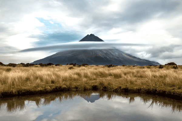
The small township of Franz Josef Glacier is located in Westland, half-way down the west coast of the South Island. Originally built on farming and forestry, the township’s dominant industry is now tourism, with visitors drawn from all corners of the globe by the area’s beautiful, dramatic landscape. The sharp peaks and valleys that make the area so attractive are a result of the landscape being very dynamic – its striking beauty was shaped by the earthquakes, landslides and floods that have occurred since New Zealand first rose above the ocean. These events will continue to occur in the future, and thus threaten human society with a wide range of hazards. Franz Josef, like much of Westland, is vulnerable to a range of hazard events including earthquake, flood, landslide and rockfall, and as a result the community needs to ensure it is resilient enough to live through, and prosper after, any future major hazard event.
Why is the area so risky?
Franz Josef is built right on top of the Alpine Fault. This is a fault line that runs for about 600 km along the west of the South Island, and has a history of producing a magnitude 8 or greater earthquakes a few times every millennium. When the Alpine Fault next ruptures the township is likely to be severely affected by ground rupture, intense and prolonged ground shaking and rockfall/landsliding from the adjacent steep slopes. But worse could be to come after the shaking has finished; hazard events like earthquakes rarely happen in isolation. Any major west coast earthquake would certainly trigger many large landslides, one of which could block the adjacent Callery Gorge. If large enough, this would cause a landslide dam, resulting in river water building up behind the slip. Once overtopped the dam would very likely fail, suddenly flooding the already reeling Franz Josef community. Over the following decades, the dam sediment would cause ongoing river sedimentation and flooding. This “hazard cascade” scenario is obviously catastrophic, but by no means fanciful; similar dambreaks and sedimentation were devastating in China after the 2008 Wenchuan earthquake, and a classic dambreak event occurred in the nearby Poerua River in 1999. In reality, moreover, many different scenarios are possible; a range of hazards might occur in any number of combinations, with the inevitable severe aftershocks potentially causing multiple landslides, ground collapses or tsunami in the years following the main shock.
Building knowledge
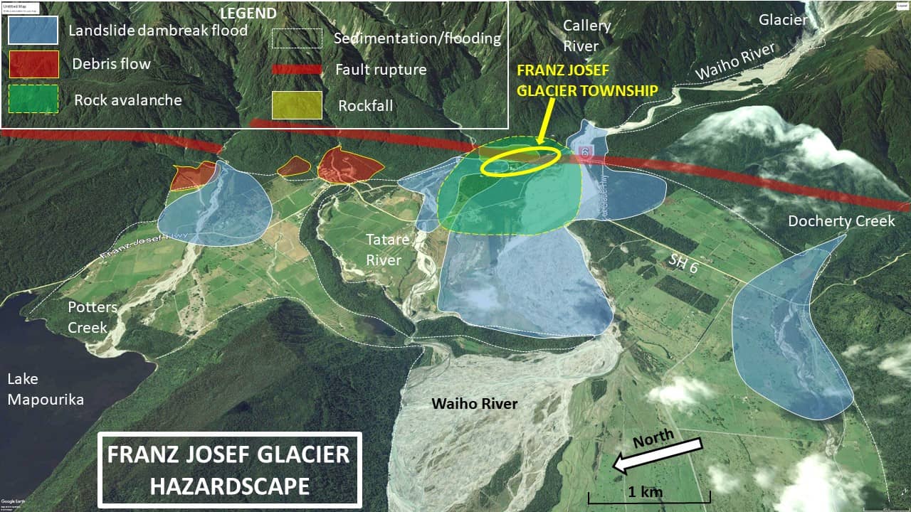
In order to be able to prepare for and increase resilience to the impacts of this wide array of natural hazards, it is important first that we know as much as possible about them. This is what a research team within the Resilience to Nature’s Challenges Hazard Toolbox is doing. By collating available hazard information and engaging with the community, the team has been working to increase understanding of the hazards in the area, and the effects that they might have. A wide range of previous studies has been collated to develop a comprehensive “hazard-scape” for Franz Josef (Fig. 1), forming the basis for working with the community and officials to develop the “impact-scape” for the area. This illustrates the range of hazard event impacts to which the community needs to increase its resilience.
Modelling potential hazard impact scenarios
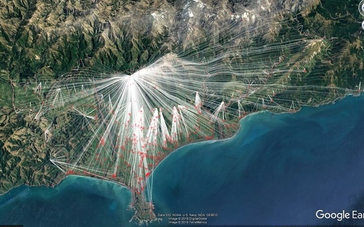
One of the projects that is currently underway involves developing a simulation model that will examine all the possible combinations and cascades of hazards affecting the town’s societal assets. PhD student Alex Dunant is building the model based on graph theory, and it will shed light on the complex hazard-impact interactions that can occur in the area. The information produced by the model will give communities, officials and service providers a better idea of the spatial and temporal distribution of impacts, and their societal consequences, enabling them to make more informed decisions about planning to reduce future impacts, and about emergency management priorities . You can find out more about Alex’s work here; Figs 2, 3 and 4 come from his work, which is using the hazards that affected the Kaikoura area after the2016 earthquake to test his Franz Josef model.
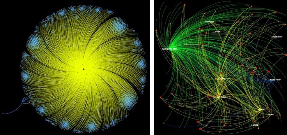
Right – Fig 3: Multi-hazard network representation for the Franz Josef area
Advance planning to reduce impact
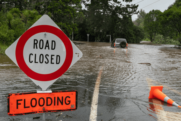
As well as developing multi-hazard-impact scenarios, the Hazard Toolbox team is also undertaking research to find out what actions and measures are required to improve the Franz Josef community’s resilience; that is, to reduce the impacts on the community of the next severe hazard event, whether it be earthquake, landslide or flood. As well as possible deaths, injuries, damage and disruption, these impacts include loss of power, communications and road access, all of which would significantly reduce the township’s ability to function even if it suffered only slightly from direct hazard impacts.
In parallel to this work, environmental and engineering consultants Tonkin + Taylor were commissioned by the West Coast Regional Council in 2017 to investigate the township’s options for increasing its resilience to natural hazards, making use of the Hazard team’s information. Three options have been developed with and presented to the Franz Josef community, each offering a different level of resilience, at a different cost. The first option has the lowest initial cost, but highest risk, in which the community would stay where it was and continue to defend itself from flooding by continuing to increase stopbank height. This is the least disruptive option, involving no relocation of homes or infrastructure, but it also has the least impact on resilience, with the entire township remaining vulnerable to the impacts of a wide array of hazards. It also includes an ongoing increase in dependence on river stopbanks that are susceptible to earthquake-induced collapse. The second option sees some of the township’s integral buildings and infrastructure being moved out of the high-risk area, while some of the community stays in its current location. This would reduce (but not eliminate) risks due to flooding, earthquakes and rockfall/landslide. The final option is the costliest, but also provides the greatest level of resilience to the Franz Josef community. It would involve moving the entire township several kilometres, away from the high-risk area. While this would permanently mitigate almost all of the current risk, it is the most disruptive option, requiring upheaval of homes and businesses, and abandonment of an area that has been occupied for generations. It also requires the highest up-front cost; however the benefits would continue to accrue in perpetuity. The full report on these options can be found here
Choosing among these three options is no easy task, and even with a relatively small population of fewer than 400 residents, reaching a stakeholder consensus in Franz Josef will likely be difficult. Another Hazard Toolbox PhD student, Kat Hore, is currently living for extended periods in Franz Josef to study the societal interactions and power structures that affect such a significant decision-making process. Kat is assessing the extent to which the consultation processes enable or deter genuine participation of local people in decision-making. You can find out more about Kat’s work here.
Moving forward
Researchers in the Hazard Toolbox team have been working closely with the Franz Josef community, Regional and District Councils, Civil Defence Emergency Management Groups and lifelines/infrastructure organisations over the past three years, and will continue to do so in the future. This close collaboration fosters communication and trust among the individuals involved, and facilitates input and ownership by all stakeholders. It also ensures that research is steered in a direction that will produce tangible, useful results that will benefit the local community and stakeholders.
The next steps for this research project involve completing the multi-hazard impact scenarios for Franz Josef, which will provide a sounder basis for decision-making than presently exists. The framework that Alex Dunant is developing for hazard and impact scenarios also has the potential to incorporate societal information, and to simulate the ongoing interactions and feedbacks between societal and infrastructural systems following a disaster, allowing presently unforeseeable situations to be identified and planned for. The outcome of Kat Hore’s embedment within the Franz Josef community during this critical time will provide much clearer understanding of how a community weighs up the wide range of hazard, impact and disruption information relating to future events, while at the same time maintaining its everyday societal and commercial functions in a dynamic political and economic environment. It will also provide insights on the approaches taken by various stakeholders to foster the participation of Franz Josef residents in creating knowledge and decision making processes.
The defining characteristic of the Hazard toolbox team’s research is the drive to make science and planning effective within a real-life context, by involvement with a community facing critical decisions about its future sustainability in the midst of a dynamic landscape. This context severely tests the ability of science to generate information that is both relevant and useful to those most threatened by future disaster events.