By Emily Lane, NIWA
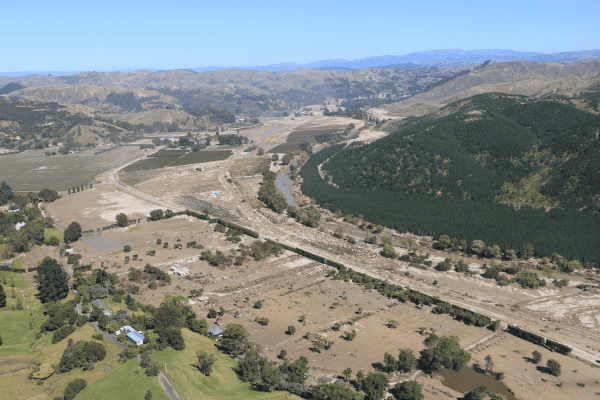
Cyclone Gabrielle was a severe ex-tropical cyclone that devastated parts of the North Island of New Zealand in February 2023. The scope of this project was to provide flood risk and flood modelling support, as well as engagement and communications support.
The aim of the research was to better understand the scale of flooding caused by the cyclone and how it affected Tairāwhiti and Hawke’s Bay. It also included support to enhance current resource capability and capacity, and the development of greater coverage of flood mapping information across the regions to fill in gaps. This will enable significantly better flood event planning systems can be implemented.
Overtime, it will be necessary to understand how the mobilised sediments caused from the multitude of landslips around the catchments will influence the flood hazard across the region into the future – this is an emerging research need.
Meanwhile, the main outputs of this project consist of:
- recalculation of flood frequency curves for designated locations in Hawke’s Bay and Tairāwhiti,
- hydraulic modelling assessments over these regions to create wider coverage and understanding of the flood inundation hazard,
- assessment of the residual risk of stopbanks failing, and
- recommendations for future flood resilience work.
Key Findings
Key findings from our collaborative finding to date are:
Modelling & Mapping Outcomes
There is a need for consistency in mapping across the regions as the risks are currently unquantified in many locations. This has led to a lack of preparedness and awareness, and hence uninformed decision making. This research has created region-wide mapping outputs at a coarse and high level. These require refinement but provide a basis to protect against future flood events and support land use planning decisions which will enhance the regional resilience to flooding.
Resourcing
Funding and staff resources are under pressure within our Regional Councils. There are currently insufficient resources to support event preparedness and response/recovery. Additionally, the resourcing challenges to date are such that the flood hazard has not been mapped for large areas of the regions and hence a regional understanding of flood risk has not been possible to date.
This research has provided additional scientific staff support to enable post event analyses and mapping/modelling to take place. Deriving appropriate plans to deliver support through additional technical resources, both through the Local Government Association (LGA) to support council core functions and other providers from the wider scientific and engineering communities would be a valuable outcome from this event, so that future flooding events can be responded to earlier and, ideally, prepared for in advance. Regional councils should assess their technical capabilities to deliver the wider range of responsibilities associated with safely managing all forms of flooding.
Responsibilities
Regional councils should progressively take on a regional overview of all flood risk, including surface water and groundwater flood risk, to support catchment-based decisions that are made with enhancing flood resilience across the community/region in mind. This should be supported by relevant national organisations and central government agencies.
All authorities and key stakeholders should have a duty to share information / data on flood hazard and risk. Arrangements should be made so that this information is more easily shared between different organisations in preparation for, during, and after future events. Central Government, in conjunction with the LGA, should develop arrangements to provide advice and support from experienced organisations to areas dealing with recovery from severe flooding emergencies. This support should include the technical expertise to appropriately understand and unpick the event to support future flood risk planning activities.
Future Outputs
No formal outputs are available publicly yet. The team is closing out and sharing the work with local partners and mana whenua over the first quarter of 2024, at which point summary reports and outputs will be made available. The flood frequency analysis is currently in review and will be released once that is completed.
***
This rapid flood modelling work was a collaborative effort between researchers from the National Institute of Water and Atmospheric Research (NIWA), Canterbury and Auckland Universities and engineering consultants from WSP, alongside key representatives from Gisborne District Council (GDC) and the Hawkes Bay Regional Council (HBRC).