New Zealand's Changing Coastline
Te Hurihanga o te Takutai Moana o Aotearoa
State
Phase 2

Duration
2019 – 2024
Budget / Funding
$1269000
Project Leader(s)
The University of Auckland
Murray Ford
The University of Auckland
Vision
Aotearoa New Zealand has an accurate and detailed record of past and ongoing coastal change, and an understanding of its causes to support projections of future change.
Project description
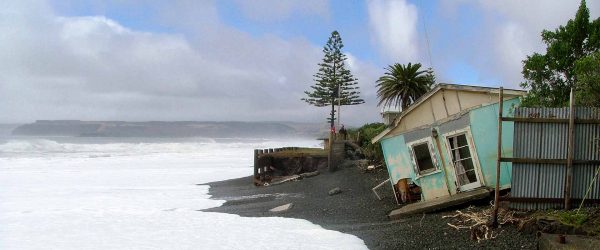
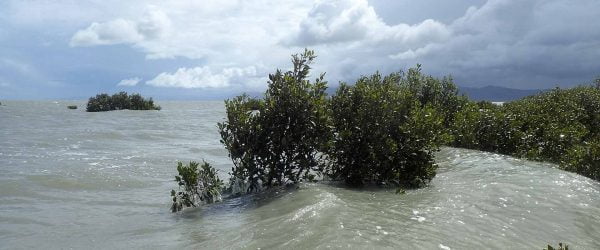
We currently have an incomplete knowledge of how our coastline is changing, where and at what rate. Coastal erosion is a significant hazard facing coastal communities throughout Aotearoa New Zealand. The risk exposure of coastal communities and infrastructure is rapidly increasing as sea-level rise accelerates and a legacy of poor coastal planning decisions takes effect.
We are creating a national coastal-change database to understand the nature and causes of past changes and to maintain a record of ongoing changes to help anticipate the future. To achieve this, we are:
- creating a publicly available geo-referenced database to record a sequence of detailed snapshots of Aotearoa New Zealand’s entire 15,000 km coastline to identify how fast our coastline is changing, and which areas are most prone to erosion
- developing new semi-automated tools that use satellite images and onsite monitoring to detect coastal change
- undertaking case study analyses of Māori oral histories of coastal change
- exploring the underlying causes of coastal change to underpin projections of future change.
Our goal is for our publicly available database of past and ongoing coastal change to be used by planners and decision-makers when deciding how to best plan for our changing coastline.
Wawata
He pūkete tōtika, āmiki hoki tā Aotearoa mō te hurihanga haere o te takutai, me te mārama anō ki te pūtake me te tautoko i ngā matapae o ngā hurihanga anamata.
Whakaahuatanga papatono
Ināianei he hukihuki tā mātou mātauranga mō te hurihanga o tō tātou takutai, ki hea, ā, pēhea te tere. He mōrearea nui te ngāhorohoro o te takutai e pā nei ki ngā hapori noho ki tai puta noa i Aotearoa. Kei te tere piki haere te pānga o te tūraru ki ngā hapori noho ki tai me te tūāhanga hoki i te tere o te pikinga o te paemoana me te pāpātanga o ngā whakataunga whakamahere koretake o mua.
E waihanga ana mātou i tētahi pātengi raraunga mō te hurihanga-takutai kia mārama ai ki te āhua me te pūtake o ngā hurihanga o mua me te pupuri i tētahi pūkete mō ngā hurihanga moroki hei matapae i te anamata. Hei whakatutuki i tēnei, e pēnei ana mātou:
- e waihanga ana i tētahi pātengi raraunga tūtohu matawhenua tūmatanui hei hopu i tētahi raupapatanga whakaahua o ngā kiromita 15,000 katoa o te takutai moana o Aotearoa hei tautohu i te tere o te hurihanga o te takutai, ā, ko ēhea ngā wāhi e tino pāngia ana e te ngāhorohoro
- e whakawhanake ana i ngā taputapu āhua-aunoa e whakamahi ana i ngā whakaahua amiorangi me te aroturuki ā-tauwāhi kia kite ai i ngā hurihanga o te takutai
- e whakahaere ana i ngā tātaritanga rangahau mō ngā kōrero tuku iho a te Māori mō te hurihanga o te takutai moana
- e tūhura ana i ngā pūtake o te hurihanga o te takutai moana hei pūtake mō ngā matapae o ngā hurihanga o anamata.
Ko te whāinga mō tā mātou pātengi raraunga tūmatanui mō ngā hurihanga takutai o mua, moroki hoki, ka whakamahia e ngā kaiwhakamahere me ngā kaiwhakatau i a rātou e whakatau i te ara tika hei whakamahere mō ngā hurihanga o tō tātou takutai moana.
Resource Outputs from this project
Article
Regional implementation of coastal erosion hazard zones for archaeological applications
An opportunity for coastal managers to incorporate heritage considerations into adaptive planning pathways.
Article
Engaging diverse knowledge holders in adaptation research
G. Cundill, B. Harvey, D. Ley, C. Singh, B. Huson, P. Aldunce, R. Biesbroek, J. Lawrence, D. Morchain, J. Nalau, N.P. Simpson, E. Totin 2024…
Video
New Zealand’s Changing Coastline
How our researchers are using aerial and satellite imagery to determine how NZ's coasts are changing and identify erosion hotspots.
Article
Aotearoa New Zealand’s coastal archaeological heritage: A geostatistical overview of threatened sites
Determining how many of Aotearoa's archaeological sites are vulnerable to inundation or permanent erosion due to sea-level rise, so we can plan to protect them.
Article
Aotearoa New Zealand’s coastal archaeological heritage: A geostatistical overview of threatened sites
A first-pass overview of archaeological heritage at risk in Aotearoa
Data Set
Pre- and Post-Gabrielle coastline mapping data
View digitised coastlines from our Changing Shoreline project team, based on aerial photographs and high resolution satellite imagery taken prior to Cyclone Gabrielle, and after.
Article
A methodology for National Scale Coastal Landcover Mapping in New Zealand.
Collings, B., Ford, M., & Dickson, M. (2022). A Methodology for National Scale Coastal Landcover Mapping in New Zealand. Remote Sensing, 14(19), 4827. MDPI AG.…
Article
Aeolian sand sedimentation through excavated foredune notches during oblique onshore incident winds
Nguyen, D., Hilton, M. & Wakes, S. (2022) Aeolian sand transport thresholds in excavated foredune notches. Earth Surface Processes and Landforms, 47(2), 553– 568. https://doi.org/10.1002/esp.5271
Article
Incident wind approach angle and topographic steering through excavated foredune notches
Duc Nguyen, Mike Hilton, Sarah Wakes, Tom Simons-Smith. Incident wind angle and topographic steering through excavated foredune notches. Geomorphology, Volume 395, 2021. https://doi.org/10.1016/j.geomorph.2021.107982
Article
Identifying coastal land cover types using a hybrid approach of optical and SAR satellite data in the Auckland region
Validating a hybrid rule-based and machine learning methodology developed in Google Earth Engine that utilises freely available satellite data.
Article
Communicating drivers of environmental change through transdisciplinary human-environment modelling
Allison, A. E. F., Dickson, M. E., Fisher, K. T., & Thrush, S. F. (2021). Communicating drivers of environmental change through transdisciplinary humanenvironment modeling. Earth's…
Article
Sandy beaches can survive sea-level rise
Cooper JAG, Masselink G, Coco G, Short AD, Castelle B, Rogers K, Anthony E, Green AN, Kelley JT, Pilkey OH, et al. 2020. Sandy beaches…
Article
Coastal cliff erosion in Aotearoa New Zealand and the potential impacts of sea level rise
Dickson, Mark, Thompson C. 2020. Coastal cliff erosion in Aotearoa New Zealand and the potential impacts of sea level rise. In: Hendtlass C, Morgan S,…
Article
Modelling gravel barrier response to storms and sudden relative sea-level change using XBeach-G
Brown SI, Dickson ME, Kench PS, Bergillos RJ. 2019. Modelling gravel barrier response to storms and sudden relative sea-level change using XBeach-G. Marine Geology. 410:164-175.…
Article
Our Changing Coastline
Researchers from our Coastal Programme contributed an article to Build Magazine.
Article
80 Years of Shoreline Change in Northland, New Zealand
The first step in an ambitious project to map national-scale shoreline change in New Zealand over the past century.
Related projects