In the 2021-22 year, RNC research outputs and tools have informed decisions relating to coastal planning, infrastructure planning, and emergency management.
Consistent engagement over many years between Volcanoes programme researchers and Taranaki Civil Defence and Emergency Management (CDEM) has led to significant uptake of programme research into the region’s hazard planning. Research led by Dr Alana Weir of the University of Canterbury involved a collaborative process with Taranaki CDEM to develop a set of scenarios for potential eruption pathways. Through several workshops, this resulted in a modular scenario design that was responsive to the needs of Taranaki CDEM. The scenarios were designed to have strong scientific credibility and built on earlier research in the Resilience Challenge and Natural Hazards Research Platform. The interchangeable modules give end-users the ability to adapt and modify the scenarios beyond the life of the current research and projects.
The framework has now been adopted by Taranaki CDEM for eruption preparedness, communication, and resilience planning within the region, and has been used as the basis for custom scenarios for infrastructure stakeholders. For example, Transpower are using research insights from the work to plan for the effects of volcanic hazards on the design and operation of electrical transmission infrastructure in Aotearoa.
In 2020-21 we reported on our Weather & Wildfire programme’s wind-modelling work in Tāmaki Makaurau Auckland, which was able to provide analysis on the high wind event that led to damage to the Auckland Harbour Bridge. This work, led by Dr Richard Turner of NIWA, has generated interest from Ports of Auckland container facilities. They have sought to better understand their site wind climates and the effectiveness of their wind sensors in monitoring for high winds. Our modelling tools are being used to check wind loads on containers, with the goal of improving operations and site safety.
Meanwhile, our Multihazard Risk team is working with multiple organisations and agencies seeking to utilise the MERIT (Measuring the Impact of Resilient Infrastructure) socio-economic modelling tool to assess local economic impacts from natural hazard event scenarios. An example of this is a project underway in Canterbury led by Dr Garry McDonald of MEResearch, funded by NEMA, and involving Canterbury Lifelines Group, Canterbury CDEM, and researchers from Resilient Organisations, MEResearch and the University of Canterbury. The project is focused on connecting council-held infrastructure GIS layers, with and without hazard impacts included, to the MERIT tool. This will enable a rapid, region-specific assessment of the socio-economic impacts of natural hazard events. The project is also serving as a stocktake of what are steps required to create an online assessment tool.
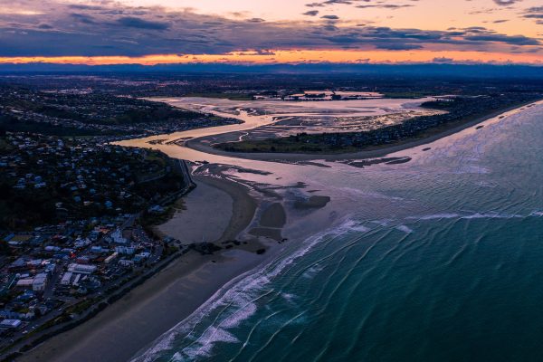
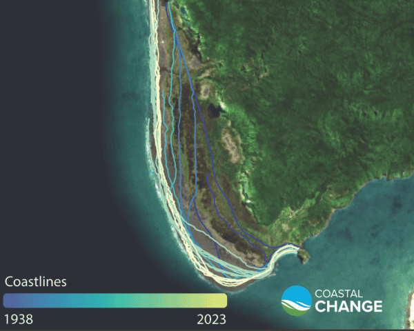
As previously reported, our Coastal team is partway through an ambitious project to map the entire shoreline of Aotearoa New Zealand, to identify trends in coastal changes and erosion hotspots. The team, led by Dr Mark Dickson and Dr Murray Ford of the University of Auckland, have completed Northland, Nelson/Tasman, Southland, and South Taranaki, and are now focused on the West Coast, North Taranaki, Otago, Auckland and the Bay of Plenty. Northland Regional Council is already using data from the shoreline mapping project in their adaptation planning work. In October 2021, NIWA in conjunction with Tonkin & Taylor released a journal paper on flooding and inundation within Tauranga harbour, as part of our Coastal Flooding project co-led by NIWA’s Dr Scott Stephens. The study was based on work commissioned by the Tauranga City Council, the Western Bay of Plenty Council and the Bay of Plenty Regional Council. The team studied the effects of incremental relative sea-level rise on exposed land areas and found coastal flooding was the biggest threat to coastal areas, rather than coastal erosion, and that low-lying areas likely to be impacted sooner than expected. In a media article, Bay of Plenty Regional Council Policy and Planning Manager Julie Bevan said local councils had been using the information to improve climate change resilience through the resource consent process for new development, while Western Bay of Plenty Council Resource Management Manager Phillip Martelli said it had used the findings to release new coastal erosion and flooding maps for Waihī Beach, Tauranga Harbour and Pukehina.