By Murray Ford
Assessing the erosional impacts of Cyclone Gabrielle across a large swathe of the country has been possible using satellite imagery collected by very-high resolution satellites and in places, aerial photographs. We have used imagery collected by operators of commercial satellites, the likes of which you see on Google maps. We also accessed aerial photos which were captured by NZ authorities and made freely available online.
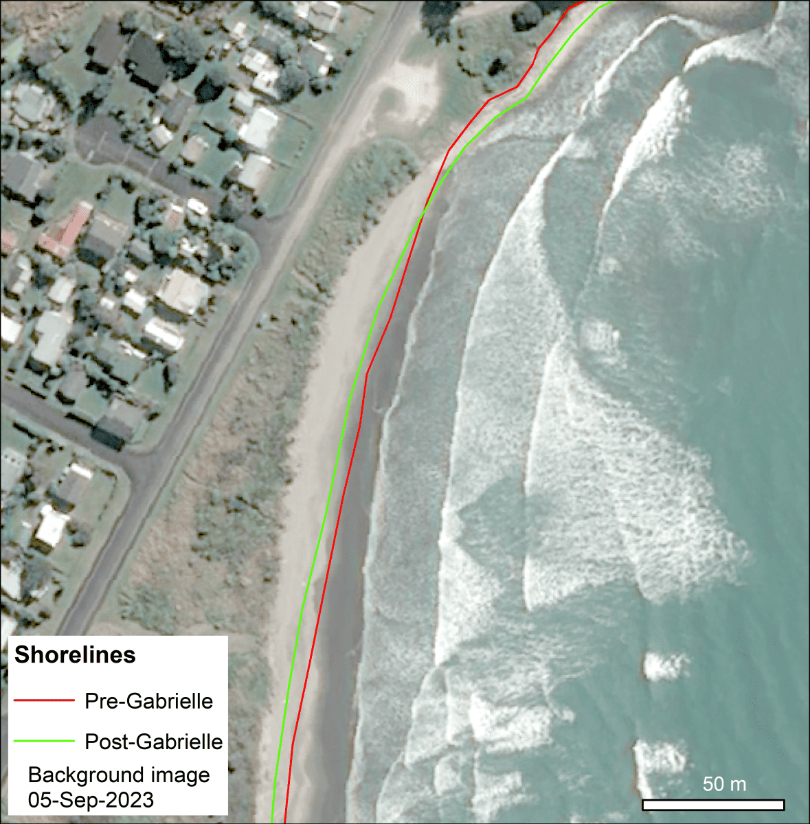
We have documented widespread erosion of beaches from Northland through the Hawkes Bay. There are several sites where >10 m of dune erosion has occurred. There are sites from all regions between Northland and Hawkes Bay that have undergone similar erosional changes. For example, Omaha, in the north of Auckland has seen dunes erode by about 8 m. While this doesn’t necessarily seem like a large amount, it’s important to note there are many houses at Omaha that are only setback 40-50 m from the toe of the dune (where the dune meets the beach). These properties have lost a considerable amount of protection provided by the dunes. Similarly, erosion of ~10 m is noticeable on many sandy beaches of the eastern Coromandel peninsula. One of the more striking examples of erosion is evident at Mahanga Beach, in northern Hawkes Bay. Here there was ~5 m of erosion because of Cyclone Gabrielle, but follow up work, including mapping from September 2023 shows an additional 15 m of erosion over winter 2023. We are acquiring additional imagery in this area to assess whether these changes are ongoing through the summer 2023/24.
Credit: Murray Ford.
Other activities and outcomes of the project so far include:
- Pre- and post-Cyclone Gabrielle shorelines have been mapped for the area from North Cape to the Mahia Peninsula in the Hawkes Bay.
- Image acquisition has begun to enable us to map a summer 2023/24 shoreline in areas that were notably impacted by Cyclone Gabrielle. This will enable us to assess how beaches have recovered from the cyclone. After reports from residents, we acquired early spring 2023 imagery of Mahanga Beach in the Hawkes Bay and have observed considerable erosion since Cyclone Gabrielle. We will sooner capture denser data of beaches that are showing patterns of continued erosion over the 12 months since the cyclone.
- Work is underway to merge the Resilience to Nature’s Challenges coastal mapping work with the Cyclone Gabrielle analysis to enable us to place the impacts of Cyclone Gabrielle into the context of 60-80 years of coastal change in Aotearoa New Zealand.
- Some mapping has been published on data.coastalchange.nz
- We have some drone surveys planned for late summer 2024.
It is hoped this research will inform councils’ mandatory hazard guidance for households, such as how close people could build to the shore and floor heights for new builds.
Find out more from the following media stories:
RNZ: Cyclone Gabrielle: Parts of East Coast lost 10 metres of shoreline, research shows
NZ Herald: Cyclone Gabrielle erosion: Whangamatā Beach lost 15 metres, study shows
(Feature image of Mahanga Beach in northern Hawkes Bay, showing the shoreline before and after Cyclone Gabrielle).