How did Resilience Challenge research have an impact in 2019-2020?
Central to our mission to accelerate natural hazard resilience is the development of new models and tools to quantify hazards and impacts in more realistic ways, providing better assessments of resilience options to decision-makers.
Development of new models is iterative, requiring repeated testing and validation, and their application usually comes at the end of an extensive period of development. RNC is driving meaningful enhancements and innovations in this area, building on work in Phase 1, the Natural Hazards Research Platform, and leveraging existing New Zealand tools such as RiskScape and MERIT.
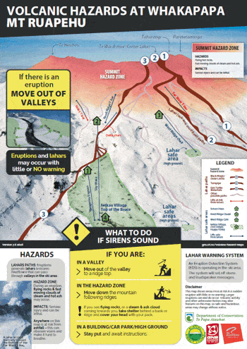
Earlier this year, Volcano programme research was integrated into updated hazard posters forTuroa and Whakapapa skifields, as part of a collaboration with the Department of Conservation. Researchers were also commissioned by Ruapehu Alpine Lifts to produce a technical report on potential lahar hazard in the Whakapapa ski area. A new lahar simulation model, calibrated to previous lahars, was used to estimate the lahar footprint and impact for a range of scenarios. Results of the report have been used to develop safety measures for the new Sky Waka gondola.
Dr Nicky McDonald and colleagues from ME Research produced economic modelling utilising the MERIT (Measuring the Economics of Resilient Infrastructure Tool) capability developed in Phase 1, to assess the economic consequences of fuel outage scenarios following the Auckland-Marsden Point fuel pipeline failure. MERIT was applied to five disruption scenarios, which were then evaluated with and without mitigation options to better understand the impact of disruption and potential value of mitigation actions for New Zealand. The report was prepared for MBIE and findings also contributed to the Board of Inquiry into the 2017 Auckland Fuel Supply Disruption.
As part of our Coastal Flooding project led by Prof Karin Bryan (University of Waikato) and Dr Scott Stephens (NIWA), Dr Shari Gallop and Masters student Akuhata Bailey-Winiata (Te Arawa, Ngāti Tūwharetoa) carried out a summer project to determine the proximity of coastal marae (located within 2km of the coast) to coastal and river waterbodies. They found that 93% of coastal marae are located in the North Island; over 45% of coastal marae are within 200 meters of the coastline; and approximately 70% of coastal marae are located below 20 meters elevation relative to mean sea level. Data will be used as a baseline for determining risk and vulnerability of coastal marae to coastal hazards and sea-level rise. Akuhata’s research was recognised by the New Zealand Coastal Society who awarded him with a Māori and Pacific Island Research Scholarship in July 2020.
Our Built Environment programme has completed new hazard maps for Bay of Plenty marae (showing fault lines, flooding, geothermal, liquefaction, and tsunami zones) using data from Rotorua City Council and Environment Bay of Plenty. The maps were provided to Te Arawa Lakes Trust collaborators, and are intended to be used to catalyse conversations with marae regarding adaptation and preparedness planning.
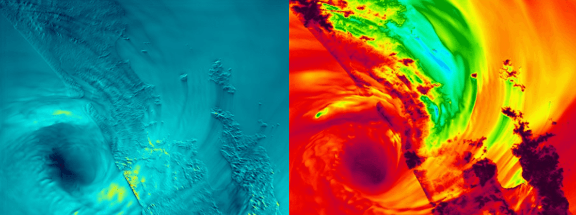
Part of our Weather and Wildfire programme involves the modelling of credible ‘what-if’ scenarios. What if the path of ex-Tropical Cyclone Cook (which did much damage in eastern Bay of Plenty in 2017) had been further west and hit our biggest population centre, Auckland? Weather scenario modelling at such fine-grid resolutions is a first for New Zealand, and allows detailed impact modelling to be carried out for a variety of coincident weather, flood, and landslide hazards, building a credible worse-case impact scenario for Auckland and surrounding districts. The early modelling is highlighting the potential for extreme impacts in Auckland, and in other areas well away from Auckland such as the higher elevations of the Kaimai ranges.
The primary goal of our Earthquake-Tsunami programme is to generate synthetic earthquakes using computer models. Big earthquakes and tsunamis (thankfully) don’t happen very often. A downside of this infrequency is that limited information from past earthquakes makes the job of forecasting future earthquakes and tsunamis challenging. One way of getting over these limitations is to generate synthetic earthquakes over millions of years using computer programmes.
The team, led by Dr Bill Fry and Prof Andy Nicol, now has a first iteration of a synthetic seismicity model for New Zealand that incorporates all of the faults used for the National Seismic Hazard Model. This is a successful proof of concept. Further, through extended international collaboration, they have produced basic ground motion predictions from this model. This is an exciting and important stepping-stone in a programme of work that aims to improve future earthquake, tsunami and landslide hazard models in New Zealand.
This case study was submitted to the Ministry of Business, Innovation and Employment as part of our 2019-2020 annual reporting.